Dingle, An Daingean or Daingean Uí Chúis a place with many names and many pubs, sits in the southwestern corner of Ireland. It is impossible to travel further west in Ireland and excepting Iceland this is the most westerly point of Europe.
County Kerry is Ireland at its finest, Dingle is Kerry at its finest. With steep mountains and long sandy beaches stretching out into the Atlantic Ocean and full of the most lively and traditional Irish pubs, Dingle contains green fields full of sheep and locals full of character.
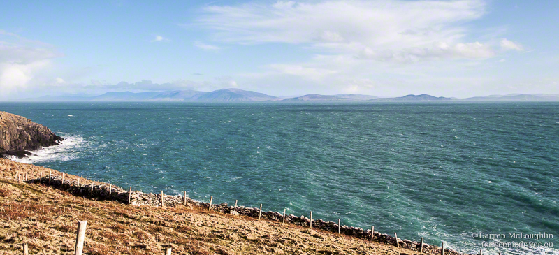
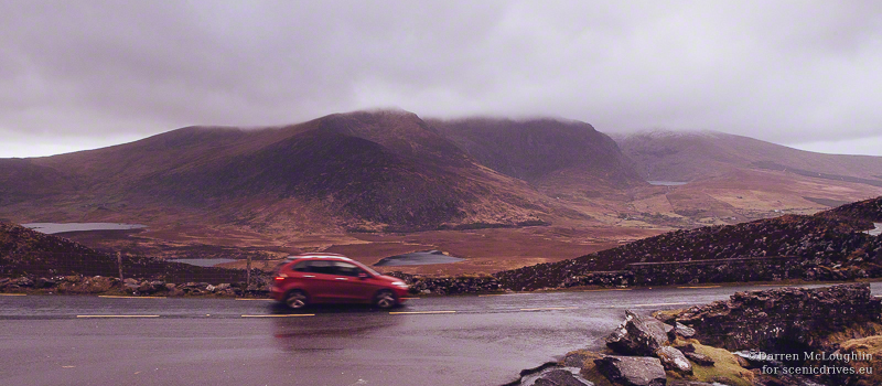
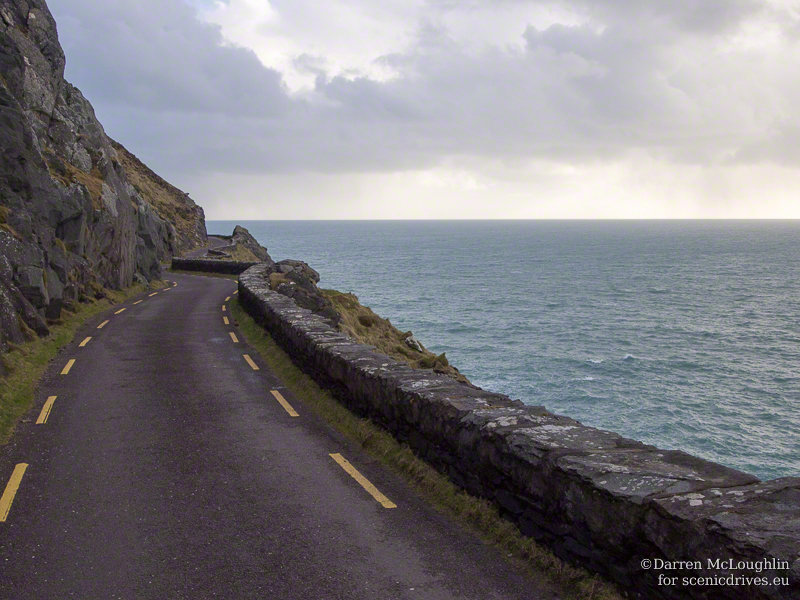
Slea Head, Dingle
The peninsula is part of the newly inaugurated Wild Atlantic Way, a 2,500km coastal route along Ireland’s Atlantic seaboard; billed as the longest continuous drive in the world the Wild Atlantic Way runs from Muff in Co. Donegal to Kinsale in Co. Cork.
Some of what awaits you on this scenic drive through Dingle.
The peninsula is a perfect place to spend two or three days with the closest access points at Shannon Airport, Cork Airport and the ferry terminal in Cork Harbour.
Basing yourself in Dingle town is a good idea, the bustling harbour and market town is the most westerly in Europe. Signposts may refer to it as Dingle / An Daingean or just simply as An Daingean.
Arriving on the Dingle Peninsula
No matter if you are coming from the south – Killarney, Kenmare and Cork or the north – Dublin, Limerick and Shannon, then your best route is to head to Castlemaine and take the R561 to Dingle / An Daingean where you will see a sign welcoming you to the peninsula –Fáilte go Corca Dhuibhne. This is the route we will be following for this article.
After a short time the scenery changes, to the south you will see the sheltered Castlemaine Harbour and the peaks of the Macgillycuddy’s Reeks, Ireland’s highest mountains. North of you, on your right is the often mist-clad mountain of Caherconree, at 835m above sea level it has a promontory fort – a wall and earthen fortifications created to defend a triangular section of mountain top dating back over 2,500 years.
Lovely Inch Strand is one of those places that looks great on a sunny, summer’s day or when the clouds are rolling in off the Atlantic. Stop, take a walk or try some surfing. From Inch it is only 30 minutes to Dingle.
From Inch the R561 continues west along the coast before joining the N86. Turn left for Dingle / An Daingean. To your right is the village of Annascaul, home of famous polar explorer Tom Crean who accompanied Captain Scott on his Discovery and Terra Nova expeditions to the south pole, and Ernest Shackleton on Endurance before retiring to open the South Pole Inn, a hostelry in his native Co. Kerry.
Statue of Tom Crean in front of the South Pole Inn
Heading for Dingle the N86 road moves inland until dropping down to the sea at the harbour town of Dingle.
Dingle Town
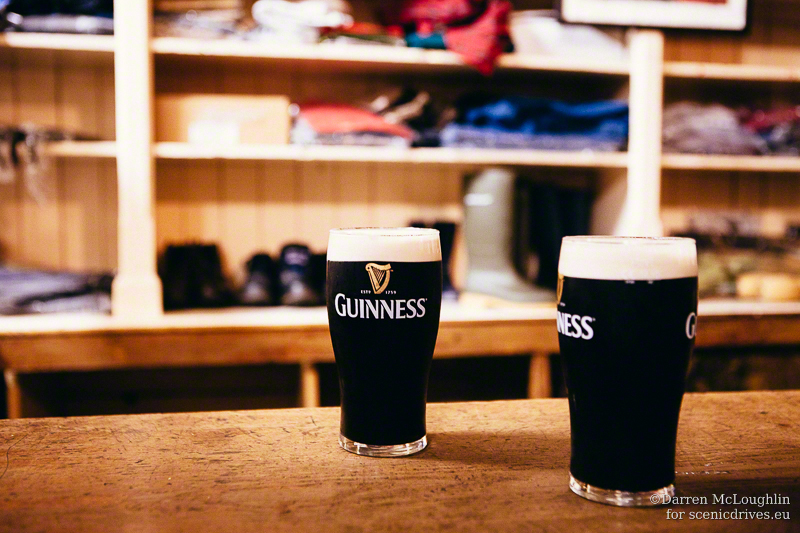
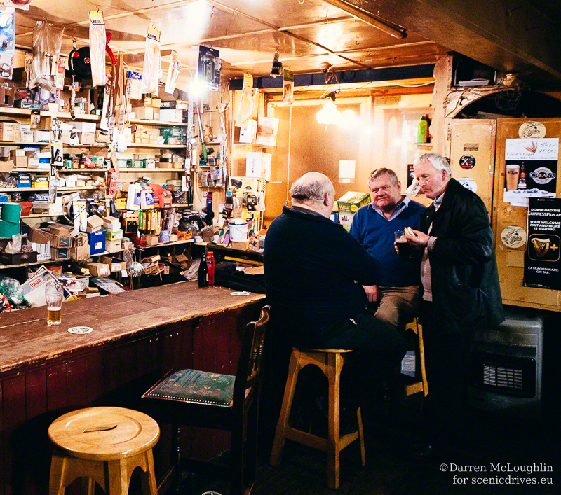
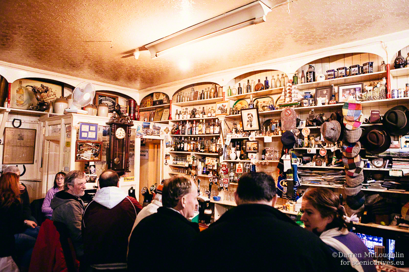
Dingle is a small town of approximately 2,000 inhabitants. It is rumoured by locals that there are 52 pubs in Dingle, so if you were to stay here for a year you could frequent one pub every week. That would be some challenge! Even if you don’t drink the pubs in Dingle are well worth visiting for live music and to see the very essence of the Irish pub. Several are hardware stores and one was a shoemaker’s workshop retaining the tools, parts and accessories, so you can still buy a pint and a pair of wellies.
In the five pubs that I happened to find myself sitting, drinking a pint I heard music in three, all of them impromptu sessions (from the Irish seisiún) involving local and foreign musicians who just happened to be there.
Dingle as well as being home to many pubs is home to the most famous dolphin in Ireland, Fungie. Boat trips are available from the harbour to see the friendly cetacean.
Slea Head Drive
This is truly one of the most scenic drives in Ireland and is a superb choice for the first post on scenicdrives.eu, narrow roads, prehistoric archaeology, a ford, beaches and tiny harbours all battered by the relentless waves of the wild Atlantic over which there are majestic views with myriad islands lying offshore. The views alone are worth the effort of driving the narrow roads – down to one lane in places.
From Dingle follow the R559 for Dunquin / Dún Chaoin and Ceann Trá, the signs are marked in brown with Slea Head Drive / Slí Ceann Sléibhe. The R559 is a circular route around Slea Head and the majority of tourist traffic flows in a clockwise direction, best to follow this advice or you will be meeting a lot of buses and cars on the narrow roads and your journey will be slower.
The R559 travels inland after Ventry then along the coast for a while, affording views south over the Iveragh Peninsula, home to the Ring of Kerry.
The precariously situated promontory fort at Dunbeg would, until the end of 2013, have been your next destination. A fort dating back at least 3,000 years and which has been noted to be in danger from falling into the Atlantic for over 120 years. It consists of four earthen defensive banks with five ditches and an internal wall, surrounded on its other three sides by sheer drops into the Atlantic, this would have been a safe place to live in turbulent prehistoric times.
In the stormiest winter to hit Ireland in living memory, a further section of the fort has fallen into the ocean and the the site remains closed for the foreseeable future.
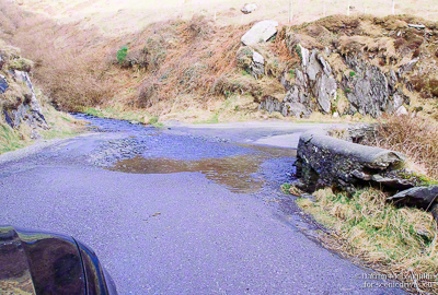
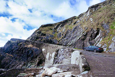
Small ford on the Slea Head Drive
Heading west still the road hugs the cliff and passes through a ford at a tight switch back. Every so often there are places to pull over and stop to enjoy the scenic views or have a picnic.
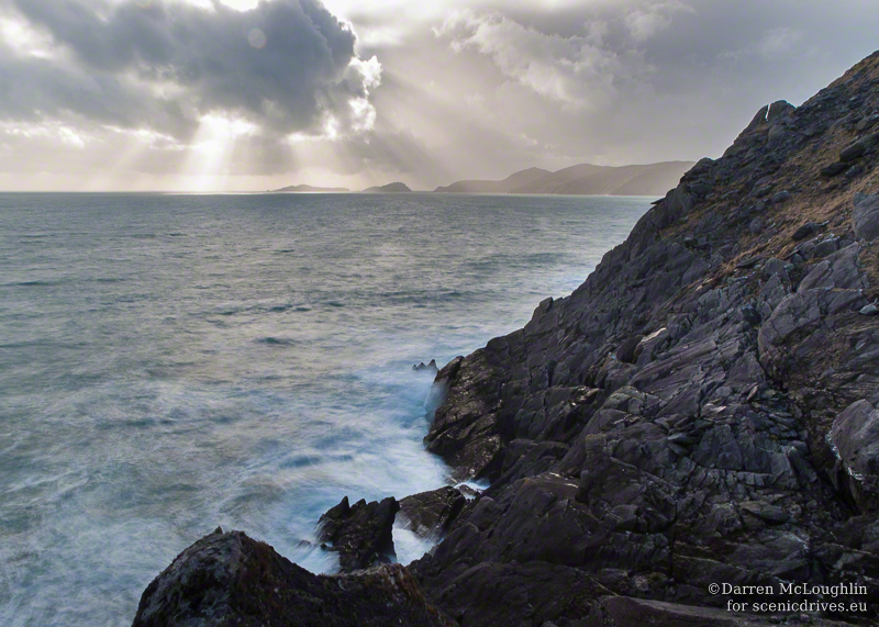
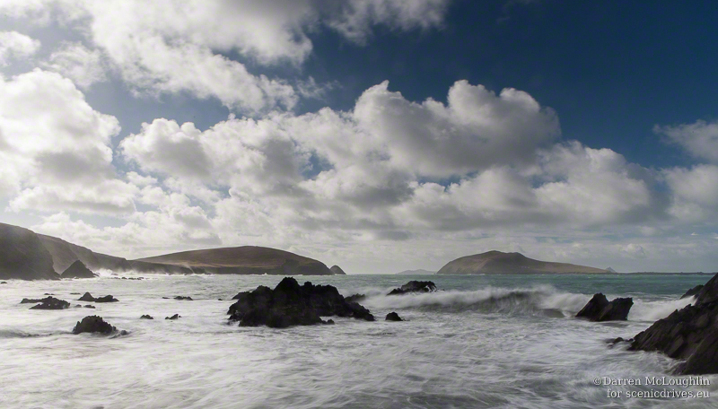
Slea Head View – rocks and sea and sky.
You’re now approaching the furthest west on the island of Ireland that you can get, save for heading on to the Blasket Islands this is the end of Europe. Nothing but 2,800 miles of Atlantic Ocean to reach Boston. Newfoundland is a bit closer at 2,000 miles but is still a formidable journey.
View from Slea Head
Beautiful Coumeenole beach is the next stop, just as the road cuts inland of a large, field-covered headland there is a small road to the left leading towards the sea where there is a car park. A small brown sign with a parking and viewpoint symbols might be visible in the hedge nearby.
Standing in the view Coumeenole, Dingle
Coumeenole is the beach featured in some scenes from the David Lean film Ryan’s Daughter. Usually it has some fine golden sandy beaches but after winter storms it can end up looking rock strewn like this, especially if the storms were like those Ireland experienced during late 2013 early 2014.
Steeply scenic road in Dingle
After taking in the views and walking on the beach head back up the hill, it is pretty steep but worth the effort of getting here.
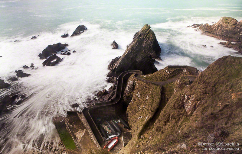
Dunquin / Dún Chaoin is a little further along the road, signposted for Blasket Island ferries. This ranks as one of the most beautifully situated harbours in Ireland. The steep little road down is too narrow and steep for cars, built for pedestrians and the occasional sheep consignment to/from the islands this little harbour also serves as the departure point to the now-deserted Blasket Islands evacuated by the Irish government to the mainland in 1953.
What a place to take the ferry from!
A longish journey will take you along the R559 through Ballyferriter to Gallarus Oratory. As you pass the Smerwick Harbour Hotel (not actually in Smerwick Harbour) there is a road to the left signed Gallarus and Slea Head Drive. Take this road and at the end of the straight, the road veers left – take the turn to the right signed Gallarus. Watch for traffic coming from the other direction!
You have two options now. Continue straight up this little road to a small car park on your left where you can walk across to the oratory, or turn left into a wide, newly created laneway where there is a visitor’s centre with video presentation, shop and toilets. The first option is free, the second option will cost €3 per person.
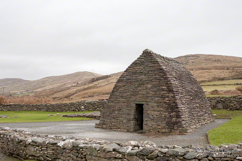
Gallarus is a little church and is reputed to be the oldest still surviving in Ireland, some optimistically date it to the fifth century but due to the dry stone construction and lack of archaeological remains it is hard to definitively date, some experts suggest the ninth to the twelfth centuries.
Whether it is 800 or 1,200 years old, it is impressive that this little oratory should have survived the raw Atlantic weather hitting land here for the first time in thousands of miles, battering its mortar-less walls and roof. Not to mention the various upheavals from the Norman conquest of Ireland, the Great Famine and the War of Independence as well as the unscrupulous developers who blighted much of Ireland in the twentieth century.
From Gallarus head back down the lane, and go straight at the Stop sign. In the next village turn right – look for a white sign with An Daingean 10km, you are now leaving the Slea Head Drive and heading back to Dingle via Kilmalkeadar Church, associated with St. Brendan and home to a Romanesque doorway, ogham stones (an early Irish alphabet) and inscribed stones.
Heading out of Dingle
I’m not sure that it is possible to leave Dingle without wanting to return, conjuring up another reason to stay.
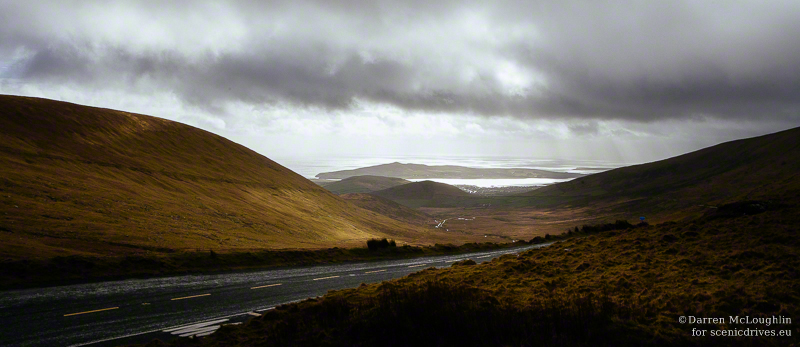
But perhaps the journey over the Conor Pass, one of the most scenic mountain routes in Ireland and its highest pass can entice the visitor to go in search of more adventures.
According to the signs if your vehicle is more than 6ft wide, weighs more than two tons then you shouldn’t be using this road!
For the Conor Pass take the R560, the scenic route…
Leaving Dingle on the Conor Pass View from the Conor Pass
In places this route is only suitable for one vehicle at a time, with overhangs of rock preventing anything wider than a standard car from passing. On the other side are sheer drops down into the valley below.
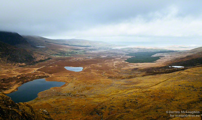
Glaciated valley below Conor Pass, Dingle
The views from the car park at the top are stupendous, looking down into the valley with its lakes and glacial features.
A breathtaking drive over Ireland’s highest mountain pass is the ideal way to end a trip around the Dingle Peninsula, a self-contained, perfect, scenic drive.
One last reason to love Dingle, not leave Dingle
Map of Dingle and Places mentioned in this article
Darren McLoughlin is a photographer, tour guide and author. He is from Ireland. Get in touch with him on Twitter @travelimages and Google Plus +DarrenMcLoughlin
This website uses cookies to improve your experience. We'll assume you're ok with this, but you can opt-out if you wish.AcceptRead More
Privacy & Cookies Policy
Privacy Overview
This website uses cookies to improve your experience while you navigate through the website. Out of these, the cookies that are categorized as necessary are stored on your browser as they are essential for the working of basic functionalities of the website. We also use third-party cookies that help us analyze and understand how you use this website. These cookies will be stored in your browser only with your consent. You also have the option to opt-out of these cookies. But opting out of some of these cookies may affect your browsing experience.
Necessary cookies are absolutely essential for the website to function properly. This category only includes cookies that ensures basic functionalities and security features of the website. These cookies do not store any personal information.
Functional cookies help to perform certain functionalities like sharing the content of the website on social media platforms, collect feedbacks, and other third-party features.
Performance cookies are used to understand and analyze the key performance indexes of the website which helps in delivering a better user experience for the visitors.
Analytical cookies are used to understand how visitors interact with the website. These cookies help provide information on metrics the number of visitors, bounce rate, traffic source, etc.
Advertisement cookies are used to provide visitors with relevant ads and marketing campaigns. These cookies track visitors across websites and collect information to provide customized ads.
Other uncategorized cookies are those that are being analyzed and have not been classified into a category as yet.
This website uses cookies to the website to work and to improve your experience. We'll assume you're ok with this, but you can opt-out if you wish. Read More
Necessary cookies help make a website usable by enabling basic functions like page navigation and access to secure areas of the website. The website cannot function properly without these cookies.
Name
Domain
Purpose
Expiry
Type
wpl_user_preference
scenicdrives.eu
WP GDPR Cookie Consent Preferences
1 year
HTTP
Marketing cookies are used to track visitors across websites. The intention is to display ads that are relevant and engaging for the individual user and thereby more valuable for publishers and third party advertisers.
Name
Domain
Purpose
Expiry
Type
VISITOR_INFO1_LIVE
youtube.com
YouTube cookie.
6 months
HTTP
Analytics cookies help website owners to understand how visitors interact with websites by collecting and reporting information anonymously.
Name
Domain
Purpose
Expiry
Type
_ga
scenicdrives.eu
Google Universal Analytics long-time unique user tracking identifier.
2 years
HTTP
_gid
scenicdrives.eu
Google Universal Analytics short-time unique user tracking identifier.
1 days
HTTP
_gat
scenicdrives.eu
Google Analytics tracking cookie.
Session
HTTP
YSC
youtube.com
YouTube session cookie.
52 years
HTTP
IDE
doubleclick.net
Google advertising cookie used for user tracking and ad targeting purposes.
2 years
HTTP
Preference cookies enable a website to remember information that changes the way the website behaves or looks, like your preferred language or the region that you are in.
Name
Domain
Purpose
Expiry
Type
NID
google.com
Google unique id for preferences.
6 months
HTTP
Unclassified cookies are cookies that we are in the process of classifying, together with the providers of individual cookies.
Name
Domain
Purpose
Expiry
Type
Ujot-J
scenicdrives.eu
---
1 days
---
LNX_KtZgyY
scenicdrives.eu
---
1 days
---
uEDfpGZryaA
scenicdrives.eu
---
1 days
---
ynqacOVMAGd-
scenicdrives.eu
---
1 days
---
icwp-wpsf-notbot
scenicdrives.eu
---
Session
---
Cookies are small text files that can be used by websites to make a user's experience more efficient. Cookies can be stored on your device if they are strictly necessary for the operation of this site. For all other types of cookies we need your permission. This site uses different types of cookies. Some cookies are placed by third party services that appear on our pages.
This website uses cookies so that we can provide you with the best user experience possible. Cookie information is stored in your browser and performs functions such as recognising you when you return to our website and helping our team to understand which sections of the website you find most interesting and useful.
Strictly Necessary Cookies
Strictly Necessary Cookise should be enabled at all times so that we can save your preferences for cookie settings.
If you disable this cookie, we will not be able to save your preferences. This means that every time you visit this website you will need to enable or disable cookies again.
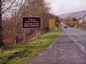 No matter if you are coming from the south – Killarney, Kenmare and Cork or the north – Dublin, Limerick and Shannon, then your best route is to head to Castlemaine and take the R561 to Dingle / An Daingean where you will see a sign welcoming you to the peninsula – Fáilte go Corca Dhuibhne. This is the route we will be following for this article.